

The Panorama Route: Dragon Mountains & Stunning Landscapes
- Jun 24
- 3 min read

We took a break from animal safaris and left the bush of Kruger behind for a day trip traveling to the Panorama Route through the Drakensberg Mountains. Drakensberg means “Dragon Mountains,” which seemed especially appropriate for a Maggie L. Walker Governor’s School Green Dragon-sponsored trip.
As is often the case with travel, getting there became part of the learning experience.

Our driver spoke nine of South Africa’s eleven official languages. He explained that he can usually determine which language to use simply by how someone says hello. As we drove through the Mpumalanga region, he also introduced us to another aspect of South African life: forestry. Mile after mile of perfectly straight rows of trees lined the landscape. These were gum trees, grown because they are fast-growing, tall, and remarkably strong. They are harvested for everything from building materials to telephone poles and fences. Once he pointed them out, we began seeing them everywhere, especially as structural supports in traditional thatched-roof architecture.

It’s one of my favorite things about travel—you often learn the most unexpected things on the way to your intended destination.
Our first stop was the Blyde River Canyon Gorge. We carefully crossed the suspension bridge spanning the gorge below. We declined the zip line and the enormous “Big Swing,” though it was great fun watching other, braver visitors give them a try.
From there, we continued to God’s Window. After climbing its seventy steps and walking through a small mountaintop rainforest created by moist air rising from the Indian Ocean, we arrived at the viewpoint. On a clear day, it is possible to see all the way to Mozambique. We didn’t have quite that much visibility, but the view was still spectacular.

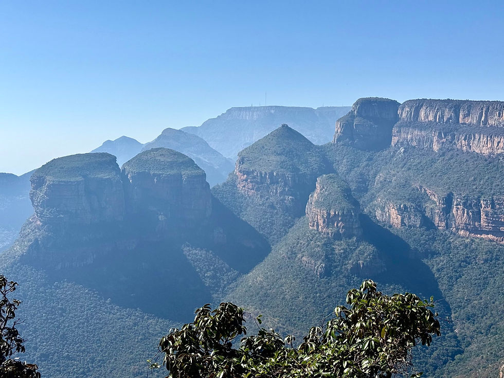
The highlight of the day, according to our driver and perhaps for us as well, was the Three Rondavels. According to local tradition, the three massive rock formations represent the wives of a chief, their rounded shapes resembling rondavels, the traditional circular homes found throughout southern Africa. The formations themselves were stunning, made even more dramatic by the sweeping horseshoe bend of the Blyde River far below.

Our next stop was Bourke’s Luck Potholes, whose rather unremarkable name does little to prepare you for their beauty. Over centuries, swirling water carved deep cylindrical formations into the rock, creating a landscape that feels almost magical. Legend has it that touching the water brings good fortune. We chose not to risk the steep descent and will have to be content with our current level of luck.

Our final destination was Lisbon Falls, named by Portuguese gold miners who once worked in the region. The falls were magnificent, plunging dramatically into the gorge below and providing one final reminder of the beauty of this landscape.

Perhaps what made the day even more special was the timing. June is winter in South Africa and still part of the quieter travel season. We arrived a week before local schools begin their winter holiday, meaning many of these sites felt almost peaceful and secluded. There were no crowds and no long waits for photographs—just the opportunity to appreciate these remarkable places in relative calm.
Throughout this trip, I have been reminded that landscape and culture are inseparable. The mountains, rivers, rock formations, and wildlife of South Africa are not merely scenic backdrops. They are the environments that have shaped stories, beliefs, architecture, and artistic traditions for thousands of years.
Thanks for following along!


Comments